News
Stay up-to-date with what's happening in EOAS

Geologists find lost fragment of ancient continent in Canada’s North
Maya Kopylova, E Tso, F Ma, and D G Pearson
Sifting through diamond exploration samples from Baffin Island, Canadian scientists have identified a new remnant of the North Atlantic craton—an ancient part of Earth's continental crust.
A chance discovery by geologists poring over diamond exploration samples has led to a major scientific payoff.
Kimberlite rock samples are a mainstay of diamond exploration. Formed millions of years ago at depths of 150 to 400 kilometres, kimberlites are brought to the surface by geological and chemical forces. Sometimes, the igneous rocks carry diamonds embedded within them.
"With these samples we’re able to reconstruct the shapes of ancient continents based on deeper, mantle rocks.”
“For researchers, kimberlites are subterranean rockets that pick up passengers on their way to the surface,” explains University of British Columbia geologist Maya Kopylova. “The passengers are solid chunks of wall rocks that carry a wealth of details on conditions far beneath the surface of our planet over time.”
But when Kopylova and colleagues began analyzing samples from a De Beers Chidliak Kimberlite Province property in southern Baffin Island, it became clear the wall rocks were very special. They bore a mineral signature that matched other portions of the North Atlantic craton—an ancient part of Earth's continental crust that stretches from Scotland to Labrador.
“The mineral composition of other portions of the North Atlantic craton is so unique there was no mistaking it,” says Kopylova, lead author of a new paper in the Journal of Petrology that outlines the findings. “It was easy to tie the pieces together. Adjacent ancient cratons in Northern Canada—in Northern Quebec, Northern Ontario and in Nunavut—have completely different mineralogies.”
Cratons are billion-year old, stable fragments of continental crust—continental nuclei that anchor and gather other continental blocks around them. Some of these nuclei are still present at the center of existing continental plates like the North American plate, but other ancient continents have split into smaller fragments and been re-arranged by a long history of plate movements.
“Finding these 'lost' pieces is like finding a missing piece of a puzzle,” says Kopylova. “The scientific puzzle of the ancient Earth can’t be complete without all of the pieces.”
The continental plate of the North Atlantic craton rifted into fragments 150 million years ago, and currently stretches from northern Scotland, through the southern part of Greenland and continues southwest into Labrador.
The newly identified fragment covers the diamond bearing Chidliak kimberlite province in southern Baffin Island. It adds roughly 10 percent to the known expanse of the North Atlantic craton.
This is the first time geologists have been able to piece parts of the puzzle together at such depth—so called mantle correlation. Previous reconstructions of the size and location of Earth’s plates have been based on relatively shallow rock samples in the crust, formed at depths of one to 10 kilometres.
"With these samples we’re able to reconstruct the shapes of ancient continents based on deeper, mantle rocks,” says Kopylova. “We can now understand and map not only the uppermost skinny layer of Earth that makes up one percent of the planet’s volume, but our knowledge is literally and symbolically deeper. We can put together 200-kilometre deep fragments and contrast them based on the details of the deep mineralogy.”
The samples from the Chidliak Kimberlite Province in southern Baffin Island were initially provided by Peregrine Diamonds, a junior exploration company. Peregrine was acquired by the international diamond exploration company and retailer De Beers in 2018. The drill cores sample themselves are very valuable, and expensive to retrieve.
“Our partner companies demonstrate a lot of goodwill by providing research samples to UBC, which enables fundamental research and the training of many grad students,” says Kopylova. “In turn, UBC research provides the company with information about the deep diamondiferous mantle that is central to mapping the part of the craton with the higher changes to support a successful diamond mine.”


Magnetite biomineralization in ferruginous waters and early Earth evolution
Kohen Bauer, Matthijs Smit, Roger Francois, Sean Crowe, and co-authors
Evolution of Earth’s surface chemistry and biology are chronicled by minerals contained in rocks. For example, magnetite, an abundant iron mineral in Precambrian sedimentary iron formations (IFs), records the chemistry and biology of the ancient oceans and atmosphere. Mechanisms of magnetite deposition in IFs are uncertain, and thus so too are records of chemistry and biology in IFs. We find that magnetite forms unusual, raspberry-like, framboidal grains through microbial iron reduction in the waters of ancient ocean analogues, lakes Matano and Towuti (Indonesia). This magnetite is a major source of Fe to the underlying sediment, and the same mechanisms likely contributed to IF deposition. The conspicuous magnetite framboids may provide a biosignature on early Earth, Mars, and other planetary bodies.

Magnetic fields at the InSIGHT landing site: A window into Mars' interior structure and evolution and an elegant probe of atmospheric and space environments
Catherine Johnson, Anna Mittelholz and the NASA InSIGHT Science team
Fluctuations in field provide clues about upper atmosphere
New data gleaned from the magnetic sensor aboard NASA’s InSight spacecraft is offering an unprecedented close-up of magnetic fields on Mars.
In a study published today in Nature Geoscience, scientists reveal that the magnetic field at the InSight landing site is ten times stronger than anticipated, and fluctuates over time-scales of seconds to days.
“One of the big unknowns from previous satellite missions was what the magnetization looked like over small areas,” said lead author Catherine Johnson, a professor at the University of British Columbia and senior scientist at the Planetary Science Institute. “By placing the first magnetic sensor at the surface, we have gained valuable new clues about the interior structure and upper atmosphere of Mars that will help us understand how it – and other planets like it – formed.”
Zooming in on magnetic fields
Before the InSight mission, the best estimates of Martian magnetic fields came from satellites orbiting high above the planet, and were averaged over large distances of more than 150 kilometres.
“The ground-level data give us a much more sensitive picture of magnetization over smaller areas, and where it’s coming from,” said Johnson. “In addition to showing that the magnetic field at the landing site was ten times stronger than the satellites anticipated, the data implied it was coming from nearby sources.”
Scientists have known that Mars had an ancient global magnetic field billions of years ago that magnetized rocks on the planet, before mysteriously switching off. Because most rocks at the surface are too young to have been magnetized by this ancient field, the team thinks it must be coming from deeper underground.
“We think it’s coming from much older rocks that are buried anywhere from a couple hundred feet to ten kilometres below ground,” said Johnson. “We wouldn’t have been able to deduce this without the magnetic data and the geology and seismic information InSight has provided.”
The team hopes that by combining these InSight results with satellite magnetic data and future studies of Martian rocks, they can identify exactly which rocks carry the magnetization and how old they are.
Day-night fluctuations and things that pulse in the dark
The magnetic sensor has also provided new clues about phenomena that occur high in the upper atmosphere and the space environment around Mars.
Just like Earth, Mars is exposed to solar wind, which is a stream of charged particles from the Sun that carries an interplanetary magnetic field (IMF) with it, and can cause disturbances like solar storms. But because Mars lacks a global magnetic field, it is less protected from solar weather.
“Because all of our previous observations of Mars have been from the top of its atmosphere or even higher altitudes, we didn’t know whether disturbances in solar wind would propagate to the surface,” said Johnson. “That’s an important thing to understand for future astronaut missions to Mars.”
The sensor captured fluctuations in the magnetic field between day and night and short, mysterious pulsations around midnight, confirming that events in and above the upper atmosphere can be detected at the surface.
The team believe that the day-night fluctuations arise from a combination of how the solar wind and IMF drape around the planet, and solar radiation charging the upper atmosphere and producing electrical currents, which in turn generate magnetic fields.
“What we’re getting is an indirect picture of the atmospheric properties of Mars – how charged it becomes and what currents are in the upper atmosphere,” said co-author Anna Mittelholz, a postdoctoral fellow at the University of British Columbia.
And the mysterious pulsations that mostly appear at midnight and last only a few minutes?
“We think these pulses are also related to the solar wind interaction with Mars, but we don’t yet know exactly what causes them,” said Johnson. “Whenever you get to make measurements for the first time, you find surprises and this is one of our ‘magnetic’ surprises.”
In the future, the InSight team wants to observe the surface magnetic field at the same time as the MAVEN orbiter passes over InSight, allowing them to compare data.
“The main function of the magnetic sensor was to weed out magnetic “noise,” both from the environment and the lander itself, for our seismic experiments, so this is all bonus information that directly supports the overarching goals of the mission,” said InSight principal investigator Bruce Banerdt of NASA’s Jet Propulsion Laboratory in Pasadena, California. “The time-varying fields, for example, will be very useful for future studies of the deep conductivity structure of Mars, which is related to its internal temperature.”
The study is one of six new papers published today that chronicle the first year of NASA’s InSight Mission.
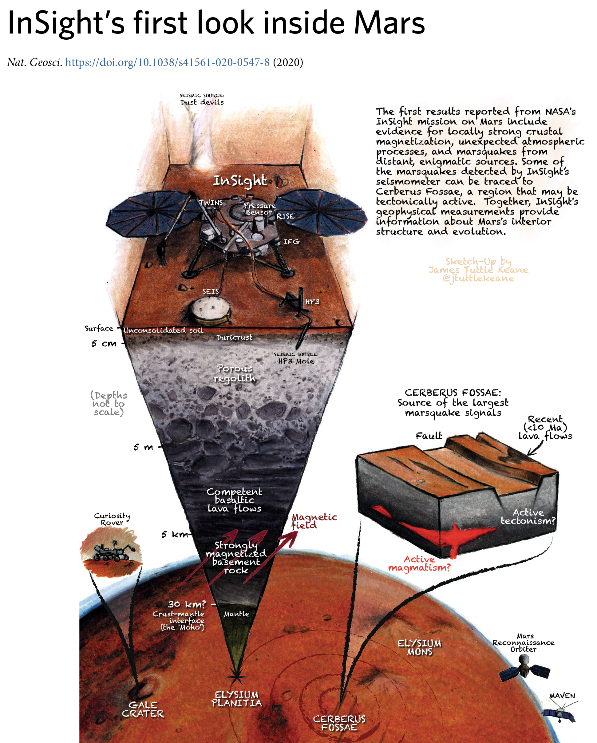
Credit: J.T. Keane; Nature Geoscience
Video: Overview of InSight mission goals

Deglaciation will cause water shortages for Alberta’s Bighorn Dam and other sites
Sam Anderson and Valentina Radic
Alberta’s largest water reservoir, the Bighorn Dam, is among four locations in the province most at risk of summer water shortages due to future glacier loss, according to new research from the University of British Columbia.
In a study outlined in Nature Climate Change, researchers examined how deglaciation in Alberta will affect regional water availability throughout the province. Current models predict that Western Canada will lose 70 to 90 per cent of its glacier ice volume by 2100.
In the first study of its kind, researchers analyzed patterns of streamflow in glacier-fed rivers and identified which communities rely on them for source water. Previous work in this field has often relied on computationally expensive and challenging studies of individual glaciers.
“In a very hot and dry year, there would be more glacier melt in the river, which kind of counteracts the lack of rain. But in a cool and wet summer, there would be less glacier melt, which would counteract the surplus of rain.”
By both projecting how deglaciation will affect stream flows and identifying where communities source water from, they were able to pinpoint where the largest changes to water supply are most likely to occur. Their analysis revealed that the most vulnerable areas to August shortages include the Bighorn Dam, which serves more than 1 million people and creates Abraham Lake along the North Saskatchewan River; the town of Rocky Mountain House, which is downstream of the Bighorn Dam; the hamlet of Lake Louise, part of the Canadian Rocky Mountain Parks UNESCO World Heritage Site; and the town of Hinton.
“These places are going to see substantial changes to their water supply,” said lead author Sam Anderson, PhD candidate in the UBC department of earth, ocean, and atmospheric sciences. “That will include having lower August flows on average, and a larger range of possible flows year to year. It's not that the rivers will run dry and they'll have no options, but these communities and locations will need to look for different water management strategies in the future that will help them manage the late summer period.”
To reach their conclusions, the study’s authors reviewed data on water flow for 194 rivers across Alberta and analyzed how their patterns differed. They found that, year-to-year, glacier-fed rivers had more stable water flows in the month of August, regardless of average yearly temperatures.
“Typically, by August, non-glacier fed rivers were below their yearly average in terms of how much water would flow into them, but glacier fed rivers had relatively high August flows consistently year to year,” said Anderson. “In a very hot and dry year, there would be more glacier melt in the river, which kind of counteracts the lack of rain. But in a cool and wet summer, there would be less glacier melt, which would counteract the surplus of rain.”
Anderson collected information on water sources for nearly 600 communities, and determined which relied on glacier-fed rivers. He found that, in the absence of glacier runoff, the Bighorn Dam will experience the largest decrease in average August flow, but the smallest increase of variability. The town of Hinton is projected to have the smallest change in August flow, but a large increase in variability. Average flows and variability for the hamlet of Lake Louise will be between those for Hinton and the Bighorn Dam. All will experience unprecedented numbers of days of below-average flow.
Anderson also discovered that eight communities located near glacier-fed rivers, including Jasper and Banff, will be shielded from the effects of glacier retreat, as they source their municipal water from deep underground aquifers.
“We went in with the assumption that communities in a highly glaciated area would be impacted, but it was interesting to find that that's not necessarily true. That’s why data on municipal water sources are important for understanding water resource vulnerability,” said Anderson.
Valentina Radic, co-author and associate professor in the department of earth, ocean and atmospheric sciences, says the research methods used can be applied to other regions whose municipal water supply relies on glacier-fed rivers.
“Our method is easily transferable to regions such as the European Alps, the Himalayas, New Zealand, and Patagonia,” she said. “All we need is readily available information like streamflow data, instead of the costly and difficult studies of individual glaciers that have informed previous work. The same can, and hopefully will be, done in other parts of the world, where actual data on glacier melt is often not available.”

CFI Award to support EOAS Microbeam Lab
EOAS has been awarded $800,000 by CFI to support acquisition of a new field emission electron microprobe under the project High Resolution Automated Mineralogy for Carbon Sequestration by Greg Dipple. Support for the remainder of the $2.0 Mill equipment purchase is sought through the BC KDF and through vendor support. The new instrument will replace an aging tungsten filament electron microprobe and provide unparalleled high-resolution automated chemical characterization of earth materials in support of research across EOAS and beyond.

Lead Found in Samples of Honey from Hives Downwind of the Notre-Dame Cathedral Fire
Researchers at the Pacific Centre for Isotopic and Geochemical Research (UBC EOAS) use geochemical tools (trace metal and isotopic analyses) to show that some of the lead released during the April 2019 fire at Notre-Dame cathedral in Paris is present in urban honey collected downwind of the fire. In the study published in Environmental Science and Technology Letters, Kate Smith and Dr. Dominique Weis collaborated with researchers in Paris, including apiarists from Beeopic, an urban beekeeping company that manages over 350 hives in Paris. Thirty-six honey samples were collected from all over Paris three months after the fire. The results of the post-fire honeys were mapped (i.e. downwind from the fire vs. elsewhere in the city) and compared to honey from pre-fire Paris and elsewhere in France. You can read full summaries of this study at UBC Science and in the New York Times.

Sibyle Moulin, a coauthor of the paper and apiarist with Beeopic, stands near beehives on the sacristy rooftop of Notre-Dame. These bees survived the fire. Photo credit: Beeopic