| |
 Outline Outline
This five page article was written for those involved in the earth sciences who have no background in geophysics. It is intended to explain very briefly how applied geophysics can contribute unique and important information that helps solve a wide range
of practical problems in the earth sciences and engineering. The article was adapted
from Geophysical Inversion: New Ways of Seeing the Earth's Subsurface, by Francis Jones and Doug Oldenburg, in Innovation, October 1998, Assocation of Professional Engineers and Geoscientists of British Columbia.
Importance of Earth's subsurface
The surface of the earth has provided the setting for most human endeavours
throughout the history of civilization, and these activities have been
profoundly affected by the largely invisible characteristics of the immediate
subsurface. Human development has depended heavily on resources obtained
from both near surface (as in construction materials) and from hundreds
to thousands of metres deep (as in metalliferous ores and petroleum based
products). We also use water from subsurface aquifers, deposit much of
our waste within the near subsurface, and build structures that must interface
safely with these shallow regions.
Physical properties vs rock type and structure
In relation to these activities, subsurface characteristics of particular
interest to earth scientists include the location, distribution and structure
of rock types, grain size distribution, and material strength, porosity and
permeability, to name a few. The earth's inherent complexity can make it difficult
or impossible to infer these characteristics from direct observation. Therefore
they often must be inferred from the distribution of more fundamental physical
properties such as density, electrical conductivity, acoustic impedance and
others. These basic properties can be measured via geophysical surveys that
record the earth's response to various types of natural or manmade signals.
The following table lists physical properties that are most commonly related
to geological materials and/or structures, and geophysical survey types that
can map variations of these physical properties.
| Common physical properties |
Associated geophysical survey techniques |
| Electrical resistivity (or conductivity) |
DC resistivity, all electromagnetic methods |
| Magnetic susceptibility |
All magnetic survey methods |
| Density |
Gravity, and seismic reflection or refraction |
| Acoustic wave velocity |
Seismic reflection or refraction |
| Other physical properties that can be usefully
mapped include chargeability, natural radioactivity, dielectric permitivity,
and porosity. |
Demand for improved modeling
Subsurface structures are usually interpreted either in terms of objects,
layers, linear features, or complex distributions. This type of information,
obtained remotely and non-invasively using geophysical surveys, is routinely
used in geotechnical, exploration and environmental activities to characterize
geological structures, estimate ore reserves, map contaminant plumes, etc.
What is involved in obtaining such information? First, field work is done
(Figure 1) which involves making many careful measurements along survey lines
on the ground or from aircraft. Traditionally,
interpretations of these measurements are often made from graphs or maps
of raw or processed data, resulting in qualitative or crudely quantitative
information about the locations, depths, and types of materials under ground.
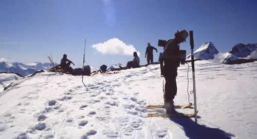
|
Figure 1: A field crew initializes
geophysical acquisition equipment used to conduct a mineral exploration
survey at a site near the Iskut River, in west-central British
Columbia.
|
In the face of ongoing demand for
increasingly quantitative information, however, sophisticated techniques are
now being used to numerically estimate the distribution of the earth's physical
properties. These modelling procedures give geoscientists a more cost effective,
reliable and accurate means of extracting as much information as possible from
conventional survey data. They also make it possible to present the rather technical information in
more visual and meaningful ways to managers, shareholders, regulatory agencies
and other interest groups.
After reading this article, it should become evident that the
application of geophysics to problems involving earth's subsurface is a
non-trivial process. A seven step framework can be used to help
understand each aspect of this process. This framework is not
referenced often in the article, but there is a one page summary referenced elsewhere which should be examined.
|
|


