
|
Geophysics foundations:
|
|
||||||||||||||||||||||||||||||||||||||||||||||||||||||||||||||||||
|
1.
|
Setup:
|
Establish the geoscience objectives, consider
conventional practice, and identify how geophysics might contribute.
|
|
2.
|
Properties:
|
Characterize materials that can be expected
and establish the likely physical property contrasts.
|
|
3.
|
Surveys:
|
Determine a suitable geophysical survey, and
design an effective and efficient field survey. Identify possible
sources of error, noise and mis-interpretation.
|
|
4.
|
Data:
|
Carry out the field survey, taking all necessary
actions to ensure compelete, high quality, and cost effective
data sets.
|
|
5.
|
Processing:
|
Plot the data, and apply appropriate processing
and analysis.
|
|
6.
|
Interpretation:
|
Interpret results in terms of physical property
distributions, and then in terms of the original geoscience objectives.
|
|
7.
|
Synthesis:
|
Combine interpretations with prior knowledge
about the problem, and with other relevant information. Decide
if your results are adequate for the particular problem. Iteration
is usually necessary.
|
This sequence of images summarizes the framework visually:
|
1.
Setup
 |
|
2. Properties
 |
3.
Surveys
 |
|
4. Data
 |
||
|
|
|
||||||
|
7. Synthesis
|
|
6. Interpretation
 |
|
5.
Processing
 |
|||
A few more details for each of the seven steps are outlined in the following table. Some terminology may need to be looked up in the glossary:
|
1.
|
Setup:
|
Establish the geoscience objectives, consider
conventional practice, and identify how geophysics might contribute.
Details of setting up the problem depend upon which of the four general task types is involved. - Locating buried objects - Mapping "apparent" physical properties - Identifying boundaries where physical property values change - Mapping detailed locations and depths of actual physical property values |
|
2.
|
Properties:
|
Characterize materials involved and their relationship to physical property contrasts.
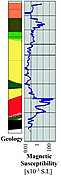
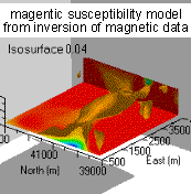
Understanding how physical properties relate to geophysical work is crucial. The most important relevant physical properties are: 1. Density; 2. Compressional wave and shear wave velocities; 3. Magnetic susceptibility; 4. Electrical conductivity (or resistivity); 5. Electrical chargeability; 6. Dielectric permittivity |
|
3.
|
Surveys:
|
Determine a suitable geophysical survey,
and design an effective and efficient field survey. Identify
possible sources of error, noise and mis-interpretation.
Successful application of geophysical techniques depends upon careful survey design and data acquisition. Matching surveys to suit the relevant physical properties is important, and forward modelling may contribute towards building appropriate expectations for data quality, noise levels, and suitablility to the task. |
|
4.
|
Data:
|
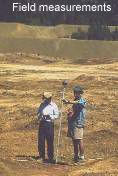
Carry out the field survey taking all necessary
actions to ensure compelete, high quality, and cost effective
data sets.
Geophysical data can be aquired in boreholes, on the surface, or in the air using aircraft. Field procedures must permit acquisition of high quality data, yet they must be economical, and safe to obtain. |
|
5.
|
Processing:
|
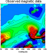
Plot the data, and apply appropriate processing
and analysis.
In nearly all cases interpretation can not proceed until some form of data processing has been applied. This may be as simple as plotting the data, or it may involve multiple numerical processing steps or data inversion. |
|
6.
|
Interpretation:
|
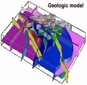
Interpret results in terms of geological
or geotechnical objectives.
The goal of interpretation is to draw conclusions or make decisions based upon the geophysical data. There are two distinct components to interpretation. The first involves estimating how physical properties are distributed. The second involves gaining some geological understanding based upon those physical property distributions. Just like much of the geosciences, non-uniqueness is a ubiquitous and persistent characteristic of most geophysical interpretations. |
|
7.
|
Synthesis:
|
Correlate with prior and alternative information,
and decide if your results are adequate for the particular
problem.
Synthesis means making sure geophysical results agree with everything else that is known about the problem. Also a judgement must be made about the effectiveness and completeness of the geophysical results, and their impact upon the initial geological, engineering, or geophysical question. |