UBC ATSC 413 - Forest-fire Weather & Climate

Case: Marshall Fire, CO

(An unusual December wildfire at the urban interface, with mountain downslope winds, frontal passage, and snow.)

Under construction.


Overview

Brief Chronology:
  • Location: near Boulder, Colorado, USA
  • Started at 11 am on 30 December 2021 as two nearby fires (Eldorado Springs Fire, and Trailhead Fire) that merged into a single fire called the Marshall Fire.
  • Spread extremely rapidly by a downslope windstorm, and moved from wildlands into towns.
  • Extinguished by snowfall on 31 Dec 2021
Fire Facts:
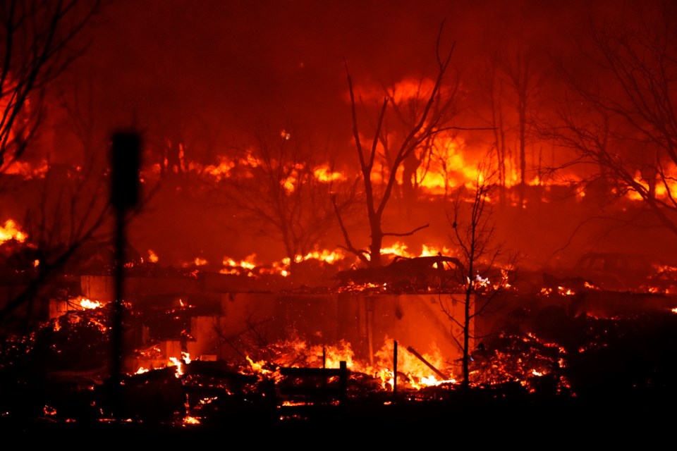
  • The Eldorado Springs Fire was human caused. Residents intentionally burning debris on their property 6 days before, let it burn out, and covered it with dirt.
  • Fast downslope winds of 129 - 161 km/hr, with gusts 177 - 185 km/hr, on 30 Dec scoured the dirt from the fire, exposing embers to oxygen and strong winds, and re-ignited the fire and blew embers into the neighboring dry grass.
     
  • Trailhead Fire was likely caused by winds causing an electric transmission line to become detached from its insulator at a power pole, allowing the wire to sway in the wind causing it to touch the neighboring transmission wire, causing electric arcing that melted and ignited aluminum that fell to the ground.
  • However, another possible, but less likely, cause of the Trailhead fire was an actively burning underground coal seam from an abandoned mine that was mined during 1863-1939.
     
  • The winds were caused by a downslope windstorm (mountain-wave / chinook conditions), which drove rapid fire spread
  • Destroyed 1091 buildings in less than 36 hours (Fovell et al. 2022, Boulder County Office of Disaster Management 2022).
  • The National Weather Service did not issue any "red flag" warning leading up to the event (CBS Colorado 2022).
  • 2440 ha burned

News Stories, including Photos and Movies

Timeline of Fire and Weather Evolution

Presentation Goals and Tips

Reading Assignment

Maps and Data on Weather and Fire Conditions that You Can Access for this Event

  1. Geography (Google Maps )
  2. Antecedent conditions: Global Wildfire Info System: GWIS (turn on the Fire Danger Forecast, and select the date) .
  3. Surface weather map from the NOAA Weather Prediction Center (WPC): Surface weather map (use the Calendar button to select the date, and then zoom to your region of interest). Also see an explanation of map symbols from the NOAA Jetstream tutorial site.
  4. Worldview satellite image: https://go.nasa.gov/47SArbp
  5. To see Synoptic Weather Maps for this case, use the Forecast Tools link at the top of this web page. Click on the Marshall Fire button, and use links in the left frame to select the weather maps you want to view. Use the arrow keys on your computer to step forward and backward in time.
  6. Another interesting paper: Juliano, T. W., Lareau, N., Frediani, M. E., Shamsaei, K., Eghdami, M., Kosiba, K., et al. (2023). Toward a better understanding of wildfire behavior in the wildland-urban interface: A case study of the 2021 Marshall Fire. Geophysical Research Letters, 50, e2022GL101557. https://doi.org/10.1029/2022GL101557.


Credits:
Top: David Zalubowski, via https://www.longmontleader.com/news-releases/communities-affected-by-marshall-fire-commemorate-one-year-anniversary-6025310
Bottom: Mulberry Street Yellow Scene Magazine