
|
Background - Earth's field |
IntroductionAll geophysical surveys involve energizing the earth and measuring signals which result from the earth's effect upon that energy. Measurements will contain information about the types and distributions of subsurface physical properties.
In the introductory section, it was noted that magnetic surveys involve measuring fields that are induced in magnetically susceptible materials by Earth's magnetic field. On this page, we provide some essential background about the static and dynamic characteristics of this natural field.
|
 |
 |
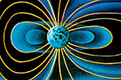
There are, in fact, three different components to Earth's field:
The convention for describing Earth's field is to have a negative pole in the northern hemisphere and a positive pole in the southern hemisphere. Therefore, the magnetic field on Earth's surface looks approximately like that given in the right-hand figure above. Using B to represent the magnetic field of Earth as a vector in three dimensions, the field at any location on (or above or within) Earth can be described in either of three ways (refer to the next figure below):
In 2004, Earth's north magnetic pole was close to Melville Island at (Latitude, Longitude)=(79N, 70W). At Vancouver D ~ 20o east, I ~ 70o down from horizontal.
 |
Sketch of coordinates used to describe magnetic fields. B is the vector representing magnetic field of the earth. |
The details of Earth's field at any location on Earth are described using a formula based upon a spherical harmonic decomposition of the field called the IGRF or International Geomagnetic Reference Field. Details about Earth's field can be found at government geoscience websites (listed below) such as the NOAA Geomagnetism home page, or the Canadian National Geomagnetism Program's home page. Resources about Earth's global magnetic field are:
The source of the main (nearly dipolar) field varies slowly, causing changes in strength, declination and inclination over time scales of months to years. Changes in the exact location of the magnetic north pole are caused by this effect. See the Geological Survey of Canada's website for a conversational history of the location of the Magnetic North pole. Declination varies very widely in Canada. The correct value of declination can be found by entering your latitude, longitude and year at the GSC's website.
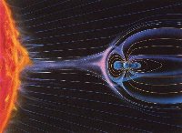 The second component of Earth's field involves external contributions due primarily to currents in the ionized upper atmosphere.
Temporal variations are often larger than geophysical anomalies. They must be accounted for in all surveys. The only exception is gradient magnetic surveys gathered using two sensors. Three figures are given in a ![]() sidebar showing examples of different types of magnetic noise that may be encountered at time scales of several days, hours, and minutes.
sidebar showing examples of different types of magnetic noise that may be encountered at time scales of several days, hours, and minutes.
The Geological Survey of Canada has a web page, which can provide graphs of diurnal variations observed at any of 11 magnetic observatories in Canada, for any day in the most recent 3 years. Find this facility by starting at the GSC Geomagnetic data page.
 Source