UBC ATSC 413 - Forest-fire Weather & Climate

Case: Kimiwan Complex, AB

(A "complex" consists of multiple fires near each other that are managed together.)

Under construction, because fire is still burning as of summer 2024.


Overview

Brief Chronology:
  • The region was primed by hot dry weather, which exaccerbated the "Spring Dip" of dry fuels.
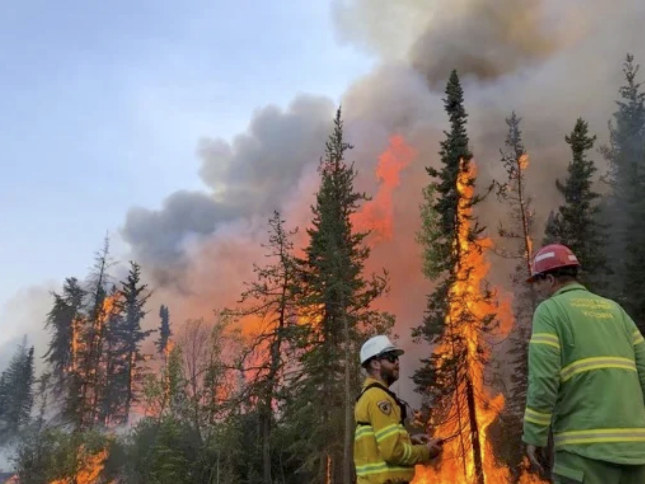
  • The fire started on 4 May 2023 by lightning, and was first reported on 5 May 2023.
  • By 10 May 2023 the fire was "out of control", and remained that way thru 16 July.
  • Three extratropical cyclones with associated fronts helped the fires to start and spread.
    • 3-5 May 2023 - Weak cyclone & front, with thunderstorms & lightning that possibly ignited the fire.
    • 15-16 May 2023 - Modest cyclone with cold front passage caused wind shift and increased fire spread into new fuels.
    • 22-23 May 2023 - South of Kimiwan was a somewhat stationary cyclone with easterly (upslope) winds over Kimiwan, causing much needed precipitation.
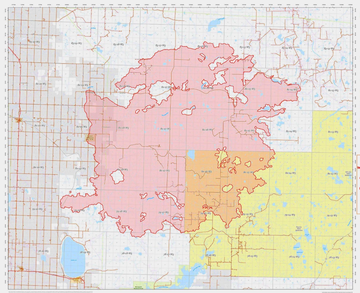
  • The main fire was “being held”as of 29 Jul 2023, at which time roughly 143,039 ha had burned.
  • On 11 Aug 2023, Alberta Wildfire declared the SWF-068 fire to be under control. Minimal fire activity. Firefighters returned to the fireground to extinguish hotspots and consolidate containment lines.
  • No "extinguished" date is listed in the Alberta wildfire database as of 7 Jul 2024. The fire apparently continued thru the winter and into year 2024 as a "holdover / carryover" fire. It still appears on the Alberta wildfire dashboard (accessed on 7 Jul 2024), with the fire number SEF-068-2023, and is listed as "under control".
Fire Facts:
  • This "complex" consists of the main fire IDs SWF-068-2023 (northwest of the Peavine Metis Settlement) and a smaller fire PWF-038 (near Three Creeks and Simon Lake).
  • Official Name: "Kimiwan Complex"
  • Total burned area: (still burning as of 7 Jul 2024) ≈ 143 kha
  • ≈ 3 months out of control
  • 237 personnel, 9 aircraft, and 34 items of heavy equipment were fighting this fire as of 29 Jul 2023
  • Evacuation Orders: (no info).
  • During active phases, it was a crown fire with initial spread-rate of 50 m/minute.
  • The terrain is mostly flat.

News Stories, including Photos and Movies

Timeline of Fire and Weather Evolution

Maps and Data on Weather and Fire Conditions that You Can Access for this Event

  1. Geography (Google Maps and Alberta topo map)
  2. Antecedent conditions: Global Wildfire Info System: GWIS (turn on the Fire Danger Forecast, and select the date) .
  3. Surface weather map from the NOAA Weather Prediction Center (WPC): Surface weather map (use the Calendar button to select the date, and then zoom to your region of interest). Also see an explanation of map symbols from the NOAA Jetstream tutorial site.
  4. Worldview satellite images: https://go.nasa.gov/3R3dP1H
    Worldview Spring Dip: https://go.nasa.gov/3PjQk37
  5. To see Synoptic Weather Maps for this case, use the Forecast Tools link at the top of this web page. Click on the Kimiwan fire button, and use links in the left frame to select the weather maps you want to view. Use the arrow keys on your computer to step forward and backward in time.
  6. Archived fire reports: https://cwfis.cfs.nrcan.gc.ca/report/archives?year=2023&month=05&day=10&process=Submit

Credits:
• Top: https://www.arcgis.com/apps/dashboards/3ffcc2d0ef3e4e0999b0cf8b636defa3
• Bottom: https://srd.web.alberta.ca/peace-river-area-update/peaceriver-update-may29-2023-0-0-1-0-0-0-0-0-0-0-0-0-0
• Alberta topo map: https://www.researchgate.net/figure/The-Planning-Areas-of-the-Alberta-Land-Use-Framework-Map-courtesy-of-Cordilleran_fig1_274056629