| |
Introduction
 This
resource provides conceptual and theoretical background about DC
resistivity surveying. It does not go into interpretation or inversion
of data, although a subsequent version of the resource will cover
interpretation in more detail. However, two activities provide an
introduction to working with raw sounding and profiling data. This
resource provides conceptual and theoretical background about DC
resistivity surveying. It does not go into interpretation or inversion
of data, although a subsequent version of the resource will cover
interpretation in more detail. However, two activities provide an
introduction to working with raw sounding and profiling data.
The content is structured so that essentials about this method
are provided on one page (Measurements and data), while more advanced
background physics and mathematics are presented on a second page
(Principles). Several appendicies are included with additional
information. Activities are included for self-testing, and for
instructor-assigned marked exercises.
DC resistivity surveys
In resistivity surveying, information about the subsurface
distribution of electrical conductivity is obtained by examining how
currents flow in the earth. DC (direct current) resistivity methods
involve injecting a steady state electrical current into the ground and
observing the resulting distribution of potentials (voltages) at the
surface or within boreholes.
Like all geophysical processes, DC surveys can be described in
terms of input energy, the earth's physical properties, and signals or
data that are measured.

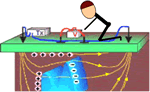
Using the same colour scheme as the flow diagram above, Figure
2 shows how this conceptual framework applies for DC methods. The energy source is a pair of electrodes that inject a well-known current into the ground at known locations (Fig. 2a). The earth affects
this energy because variations in the electrical conductivity of
subsurface structures will bend the current flow lines (Fig. 2b). The measured signals or data (Fig. 2c)
will involve measurements of voltage at the earth's surface or within
boreholes. This type of data contains information about how charges
become distributed at boundaries where electrical conductivity changes.
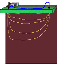 2a. The energy source is a controlled DC electrical current injected into the ground.
 |
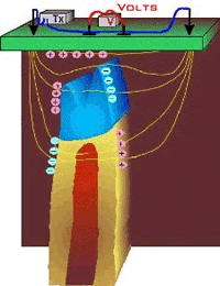
 2b. Increases and decreases in electrical conductivity cause current paths to converge and diverge respectively.
 |
 2c. Data are voltages caused by charges accumulating due to current flow.
 |
For each placement of the transmitting electrodes, several
voltages will often be measured at different locations. Therefore, the
complete data set includes measured voltages with known currents and
electrode geometries. In order to create maps or graphs of raw data for
quality assessment or for direct interpretations, it is usual to
convert the data into a form that has units of resistivity. Such
results are most commonly used as the input for DC resistivity
inversions, in which the results will be 1D, 2D or 3D models of how
subsurface conductivity is distributed.
The physical property - electrical conductivity
 Electrical
conductivity (or resistivity) is a bulk property of material describing
how well that material allows electric currents to flow through it.
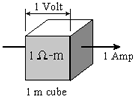
Consider current flowing through the unit cube of material shown to the
right: Electrical
conductivity (or resistivity) is a bulk property of material describing
how well that material allows electric currents to flow through it.
Consider current flowing through the unit cube of material shown to the
right:
- Resistance is simply the measured
voltage over the measured (known) current (which is Ohm's Law).
Resistance will change if the measurement geometry or if the volume of
material changes. Therefore, it is NOT a physical property.
- Resistivity is basically the
resistance per unit volume. It is defined as the voltage measured
across a unit cube's length (volts per metre, or V/m) divided by the
current flowing through the unit cube's cross sectional area (Amps per
metre squared, or A/m2). This results in units of Ohm-m2/m or Ohm-m. The greek symbol rho,
 , is often used to represent resistivity. , is often used to represent resistivity.
- Conductivity, often represented using sigma,
 , is the inverse of resistivity: = 1/.
Conductivity is given in units of Siemens per metre, or S/m.
Millisiemens per metre (mS/m) are often used; 1000 mS/m = 1 S/m. So 1
mS/m = 1000 Ohm-m. , is the inverse of resistivity: = 1/.
Conductivity is given in units of Siemens per metre, or S/m.
Millisiemens per metre (mS/m) are often used; 1000 mS/m = 1 S/m. So 1
mS/m = 1000 Ohm-m.
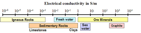
The electrical conductivity of Earth's materials varies over
many orders of magnitude. It depends upon many factors, including: rock
type, porosity, connectivity of pores, nature of the fluid, and
metallic content of the solid matrix. A very rough indication of the
range of conductivity for rocks and minerals is in the figure here.
Soils and rocks are composed mostly of silicate minerals,
which are essentially insulators. Exceptions include magnetite,
specular hematite, carbon, graphite, pyrite, and pyrrhotite. Therefore
conduction is largely electrolytic, so conductivity depends mainly
upon:
- porosity;
- hydraulic permeability, which describes how pores are interconnected;
- moisture content;
- concentration of dissolved electrolytes;
- temperature and phase of pore fluid;
- amount and composition of colloids (clay content).
Detailed discussion of geologic factors affecting this important physical property are provided in a separate location.
|
|
