Image/Video
Caption and Source


Source for next 8 photos: https://www.theatlantic.com/photo/2018/11/camp-fire-ravages-paradise-california/575461/
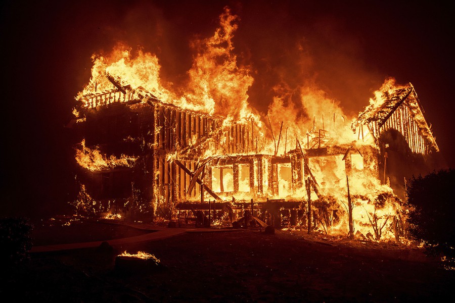
Caption:
A home burns as the Camp Fire tears through Paradise, California, on November 8, 2018. Josh Edelson / AFP / Getty
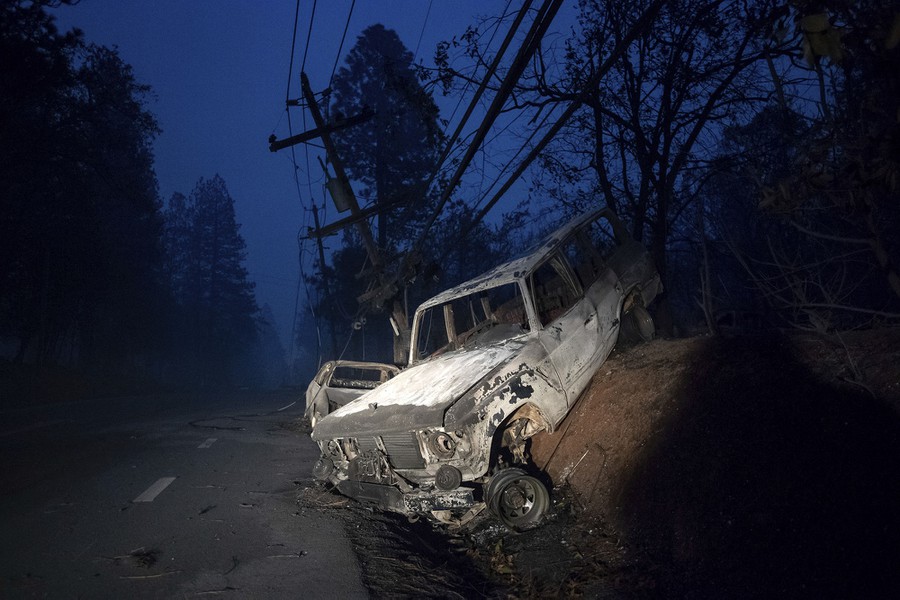
Caption:
Scorched vehicles rest on a roadside as the Camp Fire tears through Paradise on November 8, 2018. Noah Berger / AP
Caption:
The Paradise Skilled Nursing center is consumed by flames from the Camp Fire on November 8, 2018. Justin Sullivan / Getty
Caption:
A vintage car sits among debris after the Camp Fire passed through Paradise, California, on November 8, 2018. Noah Berger / AP
Caption:
A Jack in the Box fast-food restaurant in Paradise burns as the Camp Fire tears through town on November 8, 2018. Josh Edelson / AFP / Getty
Caption:
A chimney remains at the site of a home burned in the Camp Fire on November 8, 2018. Justin Sullivan / Getty
Caption:
The Camp Fire rages through Paradise, California, on November 8, 2018. Noah Berger / AP
Caption:
A home burns in Paradise, California, on November 8, 2018. Noah Berger / AP


Before and after gifs provided by The Weather Channel.
Caption:
The Black Bear Diner's iconic bear stands alone in front of the destroyed restaurant. (Google Earth and Josh Edelson/Getty Images)
Source:
https://weather.com/news/news/2018-11-13-paradise-fire-before-after-photos
Caption:
This N That, a consignment store in Paradise, is overrun by flames.
(Google Earth and Josh Edelson/Getty Images)
Source:
https://weather.com/news/news/2018-11-13-paradise-fire-before-after-photos

Firefighters make progress in California Camp Fire as search continues for missing (Nov 16, 2018)
Caption:
One of the neighbourhoods ravaged by the Camp Fire in Paradise. On Thursday, 130 people remained unaccounted for in the Northern California town and its surrounding area. (Josh Edelson/AFP/Getty Images)
Source:
https://www.cbc.ca/news/world/california-wildfires-thursday-1.4906959

In photos: Before and after the fury of a California wildfire
Caption:
Satellite images showing part of Paradise, California, before and after the Camp fire. Photo: Satellite image ©2018 DigitalGlobe, a Maxar company.
Source:
https://www.axios.com/2018/11/20/camp-fire-california-wildfire-before-after-photos
https://www.youtube.com/watch?v=JSAHEhtlA-0&ab_channel=CaliforniaHighwayPatrol
Paradise Lost - Inside the Camp Fire
Firsthand stories and videos of first responders helping people in Paradise CA evacuate.
https://www.youtube.com/watch?v=F3OX1PR2SCM&ab_channel=FRONTLINEPBS%7COfficial
Fire in Paradise (full documentary) | FRONTLINE
Note that this video is nearly an hour long.
Caption:
"Fire in Paradise" - A year after the devastating Camp Fire, FRONTLINE examines who’s to blame and why it was so catastrophic. With accounts from survivors and first responders, the documentary tells the inside story of the most destructive fire in California's history, its causes and the impact of climate change.
https://www.youtube.com/watch?v=wmuvZpC7AS4&ab_channel=JohnKlepps
Paradise, Ca-11/8/2018-Camp Fire
A local’s personal experience evacuating from Paradise. Note that this video is over an hour long.
Caption:
This is documentation of the Camp Fire as it swept through Paradise, CA. Every picture and video that I took that day, in chronological order. The volume does jump around a bit due to wind or passion/worry in my voice.
https://www.youtube.com/watch?v=5yQNXPg-pEU&ab_channel=GuardianNews
Moment 'fire whirl' forms during California Camp Fire
News video from within the fire.
Caption:
The ABC reporter Laura Anthony has captured the moment a fire whirl formed during the Camp Fire near the town of Paradise, northern California. The phenomenon, sometimes called a 'fire devil', is created when cool and hot air merge, creating a swirling effect. The inferno covered 111,000 acres on Sunday and remains only 25% contained
https://www.youtube.com/watch?v=TcI-f4jf1JM&ab_channel=GlobalNews
Dangerous Santa Ana and Diablo winds drive California wildfires
Explanation of Diablo and Santa Ana winds. Similar winds (locally called ‘Jarbo winds’) allowed Camp Fire to move quickly.
https://www.youtube.com/watch?v=dcJKFjNtpWo&ab_channel=CaliforniaFireScienceConsortium
Meteorology and Weather Associated with Extreme Wildfires in Coastal California
34 minute lecture that goes over fire weather basics, nocturnal drying events, Diablo winds, and observations of plume dynamics.
https://www.youtube.com/watch?v=nwup6tA_OzQ&ab_channel=VICENews
The Deadliest Wildfire In California History
VICE news breakdown of the fire, especially during and after the flames passed through Paradise CA.
Content Warning: Discussion of death and searching for missing people.
Paradise residents recall horrifying escape from the Camp Fire: 'This should never happen again'
Two videos embedded into the article, with the first being longer and containing content from multiple people. Clips are from residents in their cars evacuating Paradise.
(Site may not load when opened, and will say “page unavailable”. Multiple refreshes may be required to load the site and watch videos).
https://www.esri.com/about/newsroom/blog/mapping-climate-resilient-camp-fire-recovery-plan/
Includes maps that show local conditions for vegetation, climate, and burn severity for the area burned in the fire. These were created in order to aid the recovery post-fire.
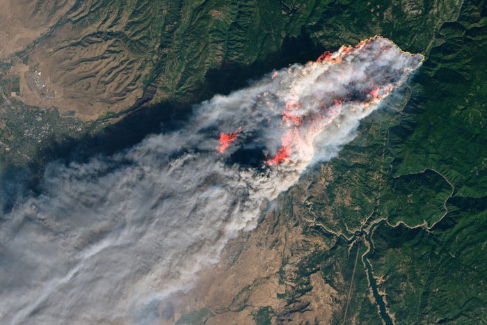

Caption:
A satellite view of Paradise, California, on November 8, 2018. NASA Earth Observatory
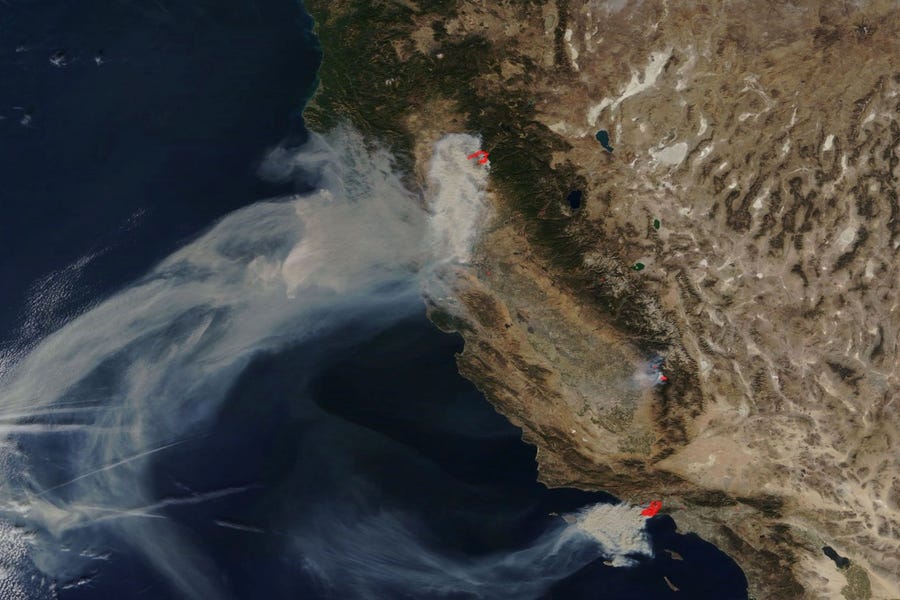
Source for next 4 photos:
Caption:
The western US on November 9, 2018. Red dots show active fires. NASA Worldview
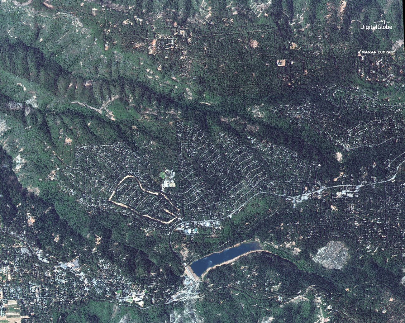
The next two images show a before and after of a residential area near paradise:
Caption:
Here's a close-up view of Magalia (top-center) and the northern tip of Paradise (bottom-left) as seen from space in September.
Paradise, California, as seen from space on September 10, 2018. Satellite image ©2018 DigitalGlobe, a Maxar company
Caption:
This WorldView-3 image shows the same view on Friday (Nov.9). Magalia, population roughly 11,000, is in flames.
Paradise, California, as seen from space on November 9, 2018. The Camp Fire burned the entire town and killed at least 29 people. Satellite image ©2018 DigitalGlobe, a Maxar company

Caption:
Power lines rest on cars that were burned by the Camp Fire on November 10, 2018 in Paradise, California. (Justin Sullivan/Getty Images/AFP)
Source:
https://www.timesofisrael.com/rescue-workers-find-bodies-after-fire-ravages-california-town/

Caption:
The burned remains of the Paradise Elementary school on Nov. 9, 2018, in Paradise. Blocks and blocks of homes and businesses in the Northern California town were destroyed by a wildfire.
Source:
https://edsource.org/2018/after-the-fire-a-school-district-gone/605038

Creator: Noah Berger | Credit: AP
Paradise from above after deadly fire sweeps through.
Source:
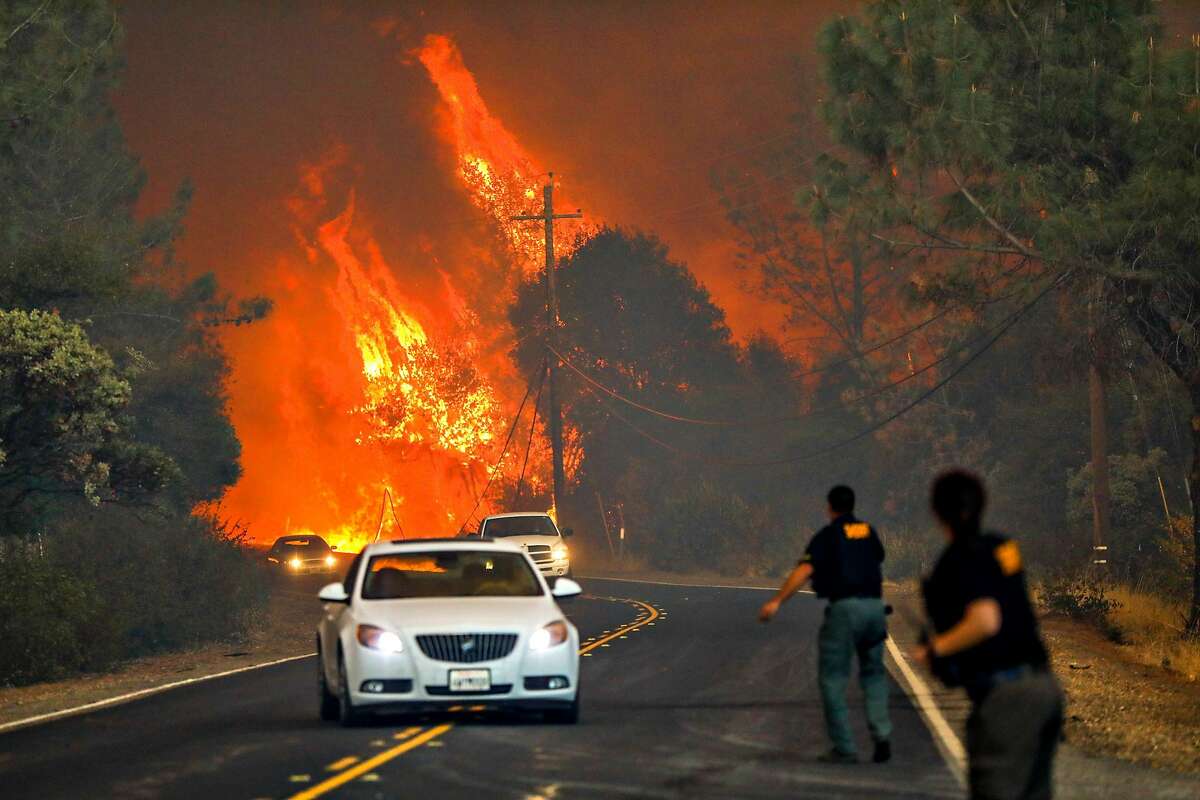
Caption:
Sheriffs yell to drivers to evacuate the area off of Pentz Road during the Camp Fire in Paradise, California, on Thursday, Nov. 8, 2018.Gabrielle Lurie / The Chronicle
Source: